American Avenue & Golden State Boulevard Realignment Project
PROJECT DESCRIPTION
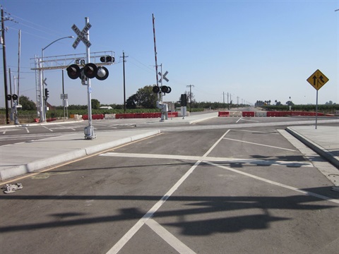
The intersection of Golden State Boulevard and American Avenue had multiple design deficiencies, including horizontal and vertical alignment of the intersection and sight distance. These geometric deficiencies, together with the proximity to the Union Pacific Railroad (UPR) tracks and the high-speed limits of the roadways (55 mph on American Ave and 65 mph on Golden State Boulevard), made it very challenging to design a major realignment along all four approaches. The diagonal alignment of Golden State Boulevard as it crosses American Avenue’s east-west alignment created acute angles due to the skewed alignment on two of the approaches (northbound to eastbound and southbound to westbound). The practical curve radius that could be designed for those turning movements were very limited. Both American Ave and Golden State Blvd have a high Average Daily Traffic (ADT) near the intersection; an average of 3000 and 4000 vehicles per day, respectively.
Golden State Blvd runs parallel to SR 99, and because there is an onramp to the highway at American Ave, many drivers make left or right turns onto American Ave to access that onramp. The improvements straighten American Ave at the intersection and included right and left turn pockets and signalization on all approaches, which will eliminate the sharp turns and create a more efficient intersection for drivers.
OBSTACLES OVERCOME
The configuration of the west side of the intersection was confusing for drivers. Approximately 100 feet west of the intersection, the eastbound approach turned abruptly southeast, continued parallel to Golden State Blvd for approximately 200 feet, then bent sharply to the northeast again to make a perpendicular connection with Golden State Blvd. The site condition provided less than 50 feet of stack length (two passenger vehicles or one large tractor-trailer) for drivers waiting to cross or turn onto Golden State Boulevard. Additionally, the tight turn radii and narrow width of the existing configuration did not adequately allow truck traffic to make turning movements without encroaching on the opposing traffic lanes, thereby causing congestion and jeopardizing the safety of the intersection. On the east side, there was approximately 40 feet of stack length between the westbound stop sign and the UPR crossing. 40 feet is room enough for two cars but is not enough for even a single large tractor-trailer to stop between the stop sign and the UPR crossing. This created a potentially dangerous situation for a tractor-trailer stopped at the stop sign when its rear end is on the tracks.
On the east side of the intersection, the configuration did not provide adequate sight distance, nor did it provide a smooth transition over the UPR tracks. Westbound approaching traffic had to traverse an abrupt upslope followed by down slope, including approximately 2.5 feet of vertical grade difference within 85 linear feet, to the stop sign on the east side of Golden State. That same space included a 100-foot-radius horizontal curve to the south which deflected the road nearly 45 degrees to become perpendicular to Golden State Blvd. Navigation of the intersection over the tracks was tricky because the high centering caused many vehicles, particularly trucks and tractor-trailers, to scrape the bottom of their vehicle when crossing the UPR tracks, which introduces the potential to lose control. The profile of Golden State Blvd at the intersection was raised approximately 2.5 ft to eliminate the abrupt change in elevation.
It took several years to initiate an agreement with UPRR and to obtain approval of the County’s project plans. The project was originally part of a road reconstruction project on American Ave. between Peach Ave and Temperance Ave; however, when the agreement with UPRR was finally reached, the County had to proceed with the intersection improvements as a stand-alone project in order to prevent the federal funding from expiring. The environmental process required that some of the properties be studied for inclusion in the National Register of Historic Places, but those properties were not eligible. Two properties subsequently went through the eminent domain process before they were settled.
The proximity of Golden State Boulevard, the UPRR tracks, and Peach Ave just to the east In order to accomplish signalization of the intersection, preemption of the normal signal phasing during railroad crossings was provided in order to determine adequate queuing capacity, particularly for west-bound traffic.
The Original bid amount: $3,148,584; Final cost: $3,135,410.
The project was the recipient of the 2022 APWA Project of the Year Award for a transportation project under $5 million.


